 |
 |
 |

THE ERUPTION OF THE FAGRADALSFJALL VOLCANOIMMINENT PUTS ICELAND ON ALERT STATE |
|
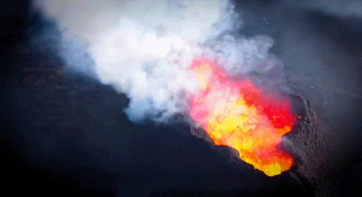
An intense series of earthquakes shook the Reykjanes Peninsula in southwest Iceland, starting on Friday, November 10, 2023. Hundreds of earthquakes were detected by regional seismometer networks and several were strong enough to be felt in Reykjavik, 50 kilometers away. A civil protection alert was triggered warning of the risk of a volcanic eruption – it would be the fourth since 2021. Iceland straddling a collapsing ditch Iceland sits majestically on the Mid-Atlantic Ridge, a place where the North American and Eurasian plates are gradually moving away from each other, at a rate of about 2 centimeters per year. In the depths of the Earth's mantle, where the rocks adopt the consistency of extremely rigid caramels, the plates agree to deform in an uninterrupted manner. On November 11, 2023, preventive measures were announced to mitigate the possible devastating effects of an impending eruption. The response plan by the authorities and the tourism industry was activated in response to recent developments, including the numerous earthquakes recorded in Reykjanes, as reported on the government website in English. As part of these measures, the town of Grindavík, home to 4,000 inhabitants, was evacuated to ensure the safety of residents. The Icelandic Meteorological Office (IMO) expresses serious concerns about the possibility of large quantities of magma spreading underground, which could erupt in the region. Scientists are carefully monitoring the region's seismic activity. Most of the recent earthquakes occurred near Grindavík, where the southwest end of the magmatic dike intrusion is estimated to be present," the IMO said. At midday on November 11, the Office meteorologist published on Twitter a map of ground deformations in the region, described as "much higher than normal". With around 30 active volcanoes over 100,000 square kilometers, Iceland strives to best manage the anticipation of volcano-related risks. In the case of Fagradalsfjall, the threat comes from underground magma that could soon emerge. An imminent eruption with the release of magma The possibility of an imminent eruption with the emergence of magma now concerns observers. Signs of this threat are manifested by a progressive deformation of the Earth's surface, signaling the intrusion of fresh magma into the crust. Over the past weekend, the situation has evolved dynamically. Parameters such as the size, number and location of earthquakes clearly indicate the filling of a crustal fracture with magma, at a depth of about 5 kilometers. Currently, the dike appears to extend directly beneath the town of Grindavik, a fishing community in southwest Iceland. If a surface eruption occurs, it could resemble those of 2021-2023 at Fagradalsfjall, with a fissure opening onto the earth, fountains of hot red molten rock, and lava flowing down the hillside from the site of the rash. This is why a preventive evacuation of the town, the nearby Svartsengi geothermal power plant, and the Blue Lagoon, one of Iceland's most popular tourist attractions, is currently underway. | |
| Simon Freeman for DayNewsWorld | |
 |
|